
i-Boating:Marine Navigation
In-app purchases

4.5star
11.9K reviews
1M+
Downloads

Everyone
info


About this app
This Marine Charts App offers offline nautical charts, inland river navigation charts, and lake contour maps for fishing,kayaking, yachting & sailing.
First marine navigation app to have boat route assistance with Voice Prompts. All features of a Marine Chart plotter in one app!
It supports Nautical Charts course up orientation. Incl Tide Charts & Currents prediction for nautical navigation.
Create new boat routes / Waypoints, or import existing GPX/KML routes on device. Has Marine AIS(NMEA) support.
►FEATURES
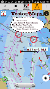
√ GPU accelerated offline vector NOAA charts/ENC charts (text stays upright on rotation)
√ Lake depth map shading/safety lake depth contours:custom boat safety depth
√ Maritime Aids to Boat Navigation : Beacons,Buoys,Boat Launch areas,Boat Ramps,Marina, Fishing Attractors
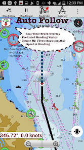
√ Record marine tracks, Autofollow with real-time track overlay
√ Voice Prompts for marine navigation
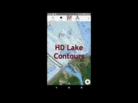
√ HD 1ft/3ft depth lake contour maps for anglers for selected lake maps: for fishing/trolling(freshwater/saltwater).
√ GPX/KML for boat route.
√ Seamless marine chart quilting: Details from Coastal, Approaches,Harbour & Inland ENC (Electronic Marine Charts)
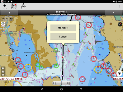
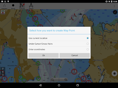
√ Waypoints
√ Tide & Currents.
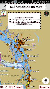
√ Marine AIS
√ Anchor Alarm
√ Magnify Text & Icons
√ Wind Prediction Overlay
√ Bearing True/Magnetic
► Fishing Hot Spots AI
► Lake Temperature Maps(Thermoclines accurate to 1°F (0.5° C)
► MAPS
All details of marine chartplotters!
Unlimited updates for 1 year.
USA: Maps incl coverage of NOAA marine charts,ENC,USACE inland river maps & freshwater lake bathymetry maps for more than 50K lakes. Charts incl HD/1ft bathymetry for selected lakes. Incl NOAA marine charts(rasters) w/ NOAA ENC coverage.
Canada:CHS data Incl Great lakes(US & Canada sides),Alberta & Ontario lakes,Lake Simcoe&Trent Severn Canal,Quebec reservoirs.
UK/Ireland: UKHO marine charts
Germany:BSH charts,Waterways & rivers.
France
Europe Inland Rivers:Donau/Danube/Dunaja,Rhine,Rhein,Garonne,Moselle,Drava,Sava
Australia
Netherland/Holland
Croatia
Finland
Norway
Sweden
Brazil
Spain
Malta,Cypress, Mediterranean Sea
Caribbean
New Zealand
Denmark,Greenland,Faroe
Seychelles,Mauritius,Tanzania
Falklands
Malaysia,South China Sea
Persian/Arabian Gulf,Red Sea
South Africa
Argentina
Iceland
Fiji
Estonia,Latvia,Poland,Lithuania
Turkey,Greece,Italy
►Instrumentation
√ Marine AIS & (NMEA AIS and GPS - TCP/UDP)
√ Wind direction & Speed,Marine Sonar depth,Water temperature
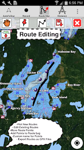
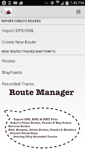
►ROUTE MANAGEMENT/TRIP PLANNING
√ Create/Edit/Reverse Boat Routes
√ Waypoints mgt
√ Import GPX,KML & KMZ files
√ Share/Export Routes,Boating log,Tracks&Markers
►FEATURES for BOAT NAVIGATION
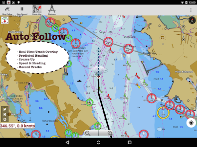
√ Auto Follow
* Real Time Overlay & Predicted Path Vector
* Course Up
* Speed & Heading
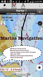
√ Route Assistance With Voice Prompts
* approaching boating route marker prompt
* Real time nautical distance & ETA
* sailing/boating off route/wrong direction
√ Record Tracks
►TIDE & CURRENTS
* High/Low Tides
* Tidal Current Prediction
* Active Current
► SHARING
* Share tracks/Boat routes/markers/Waypoints
* Export GPX files.
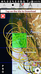
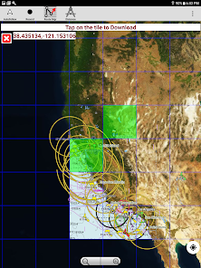
► Satellite Imagery
► USA Marine Charts
*Texas Lakes: Texoma,Eufaula,Toledo Bend
*California Lakes:Tahoe,Shasta
Pennsylvania Lakes: Raystown
Florida Lakes: Okeechobee,Kissimmee
*Minnesota Lakes: Minnetonka,Waconia,Leech,Mille Lacs
* Massachussets lakes Quabbin
*Missouri Lakes: Truman
*Ohio Lake maps Lake hoover
*Wisconsin Lakes: Winnebago,Pepin
* Utah Lake Powell,Bear
*Maine Lake Sebago
*Alaska Lakes:Winnipesaukee
*Tennessee Lake Barkley,Norris,Watts Bar
*South Carolina Lake Keowee,Hartwell,Murray
*Lake Michigan,Huron,Ontario,Superior,Erie
► Canada Lakes Maps
* Lac Saint Jean
* Ontario Lake depth maps
* Rideau Canal-Ottawa River
* British Columbia Marine Charts
* Pacific Coast-Vancouver- Haida Gwaii
* Nova Scotia South-Bay of Fundy
* Quebec-Anticosti Island
* Newfoundland
* St. Lawrence river
* Manitoba & Saskatchewan
* Georgian Bay
* Puget Sound
► UK Nautical Charts
* Scotland
* Thames Estuary
* Ireland
► Australia Marine & Lake Maps
* NSW
* Queensland
First marine navigation app to have boat route assistance with Voice Prompts. All features of a Marine Chart plotter in one app!
It supports Nautical Charts course up orientation. Incl Tide Charts & Currents prediction for nautical navigation.
Create new boat routes / Waypoints, or import existing GPX/KML routes on device. Has Marine AIS(NMEA) support.
►FEATURES
√ GPU accelerated offline vector NOAA charts/ENC charts (text stays upright on rotation)
√ Lake depth map shading/safety lake depth contours:custom boat safety depth
√ Maritime Aids to Boat Navigation : Beacons,Buoys,Boat Launch areas,Boat Ramps,Marina, Fishing Attractors
√ Record marine tracks, Autofollow with real-time track overlay
√ Voice Prompts for marine navigation
√ HD 1ft/3ft depth lake contour maps for anglers for selected lake maps: for fishing/trolling(freshwater/saltwater).
√ GPX/KML for boat route.
√ Seamless marine chart quilting: Details from Coastal, Approaches,Harbour & Inland ENC (Electronic Marine Charts)
√ Waypoints
√ Tide & Currents.
√ Marine AIS
√ Anchor Alarm
√ Magnify Text & Icons
√ Wind Prediction Overlay
√ Bearing True/Magnetic
► Fishing Hot Spots AI
► Lake Temperature Maps(Thermoclines accurate to 1°F (0.5° C)
► MAPS
All details of marine chartplotters!
Unlimited updates for 1 year.
USA: Maps incl coverage of NOAA marine charts,ENC,USACE inland river maps & freshwater lake bathymetry maps for more than 50K lakes. Charts incl HD/1ft bathymetry for selected lakes. Incl NOAA marine charts(rasters) w/ NOAA ENC coverage.
Canada:CHS data Incl Great lakes(US & Canada sides),Alberta & Ontario lakes,Lake Simcoe&Trent Severn Canal,Quebec reservoirs.
UK/Ireland: UKHO marine charts
Germany:BSH charts,Waterways & rivers.
France
Europe Inland Rivers:Donau/Danube/Dunaja,Rhine,Rhein,Garonne,Moselle,Drava,Sava
Australia
Netherland/Holland
Croatia
Finland
Norway
Sweden
Brazil
Spain
Malta,Cypress, Mediterranean Sea
Caribbean
New Zealand
Denmark,Greenland,Faroe
Seychelles,Mauritius,Tanzania
Falklands
Malaysia,South China Sea
Persian/Arabian Gulf,Red Sea
South Africa
Argentina
Iceland
Fiji
Estonia,Latvia,Poland,Lithuania
Turkey,Greece,Italy
►Instrumentation
√ Marine AIS & (NMEA AIS and GPS - TCP/UDP)
√ Wind direction & Speed,Marine Sonar depth,Water temperature
►ROUTE MANAGEMENT/TRIP PLANNING
√ Create/Edit/Reverse Boat Routes
√ Waypoints mgt
√ Import GPX,KML & KMZ files
√ Share/Export Routes,Boating log,Tracks&Markers
►FEATURES for BOAT NAVIGATION
√ Auto Follow
* Real Time Overlay & Predicted Path Vector
* Course Up
* Speed & Heading
√ Route Assistance With Voice Prompts
* approaching boating route marker prompt
* Real time nautical distance & ETA
* sailing/boating off route/wrong direction
√ Record Tracks
►TIDE & CURRENTS
* High/Low Tides
* Tidal Current Prediction
* Active Current
► SHARING
* Share tracks/Boat routes/markers/Waypoints
* Export GPX files.
► Satellite Imagery
► USA Marine Charts
*Texas Lakes: Texoma,Eufaula,Toledo Bend
*California Lakes:Tahoe,Shasta
Pennsylvania Lakes: Raystown
Florida Lakes: Okeechobee,Kissimmee
*Minnesota Lakes: Minnetonka,Waconia,Leech,Mille Lacs
* Massachussets lakes Quabbin
*Missouri Lakes: Truman
*Ohio Lake maps Lake hoover
*Wisconsin Lakes: Winnebago,Pepin
* Utah Lake Powell,Bear
*Maine Lake Sebago
*Alaska Lakes:Winnipesaukee
*Tennessee Lake Barkley,Norris,Watts Bar
*South Carolina Lake Keowee,Hartwell,Murray
*Lake Michigan,Huron,Ontario,Superior,Erie
► Canada Lakes Maps
* Lac Saint Jean
* Ontario Lake depth maps
* Rideau Canal-Ottawa River
* British Columbia Marine Charts
* Pacific Coast-Vancouver- Haida Gwaii
* Nova Scotia South-Bay of Fundy
* Quebec-Anticosti Island
* Newfoundland
* St. Lawrence river
* Manitoba & Saskatchewan
* Georgian Bay
* Puget Sound
► UK Nautical Charts
* Scotland
* Thames Estuary
* Ireland
► Australia Marine & Lake Maps
* NSW
* Queensland
Updated on
Safety starts with understanding how developers collect and share your data. Data privacy and security practices may vary based on your use, region, and age. The developer provided this information and may update it over time.

No data shared with third parties
Learn more about how developers declare sharing

This app may collect these data types
Location and Personal info

Data is encrypted in transit

You can request that data be deleted
Ratings and reviews
4.6
10.8K reviews

Christopher Clark
- Flag inappropriate
October 15, 2023
Fantastic navigation app for what I use it for. I use for navigation on the Great Lakes. Depth contours and ATONS have been accurate, App shows me where I'm at, and helps me get to where I'm going. I have also used for voyage planning - a purpose for which it serves adequately. It's smooth, colorful, and accurate. The price is right too! It's my goto app - even when I have garmin products aboard as well. What do you have to lose? Try it for free, pay because you love it! Castrilper
36 people found this review helpful

Michael J Wagner
- Flag inappropriate
November 4, 2022
I like this app but with a couple tweaks could be stellar. For example, show me lakes near me. If I don't spell the lake name correctly it won't find it. I also have to have name lake or, lake name, as listed or it won't find it. The search function is very limited. Also not sure how old your maps are but I recently started boating and the map on the boat is much more accurate. Unless I'm not setting things up correctly in your app. Thanks for asking for my input.
35 people found this review helpful

Ken Preston
- Flag inappropriate
September 12, 2022
I have only just begun to use this app and have not yet mastered it or used all of its capabilities. Most prominent observation is the charts for my area (at least) are splendid. It is easy to lay out a new route using charts and the crosshairs. Naming the new waypoints is also easy. I look forward to more on water use to evaluate the usefulness for navigation in reduced visibility in particular.
44 people found this review helpful
What's new
Lake Temperature
Marine Weather Forecast
Fishing AI
NMEA ALARMS:Depth+Wind
Marine Weather:Wind,Wave
Automatic Boat Routing
-UK Tide & Currents
-Magnetic Bearing
-Wind Prediction Overlay
-Magnify Text+Icons
-Anchor alarm
- Auto Pilot
-Greenland
-Custom depth shading
-Satellite imagery
-AIS &GPS NMEA TCP/UDP
-Russian rivers(Volga)
-Wind speed,direction,sonar depth,water temp
Norway,Finland,Denmark
German(Donau,Elbe,Mosel,Rhein,Saar,Weser)
Austria
Belgium
Swiss-Rhine
Elbe,Ruhr,Mosel,Saar


