Trails for everyone, forever

Home Go Hiking Hiking Guide Cherry Creek Falls

Cherry Creek Falls

Central Cascades > Stevens Pass - West
47.7457, -121.9076 Map & Directions
Length
5.0 miles, roundtrip
Elevation Gain
450 feet
Highest Point
705 feet
Calculated Difficulty About Calculated Difficulty
Easy/Moderate
Cherry Creek Falls. Photo by Dave Puhrmann. Full-size image
  • Dogs allowed on leash
  • Good for kids

Parking Pass/Entry Fee

None
Saved to My Backpack

Hike along old logging roads to a 25-foot tall waterfall on Cherry Creek just outside of Duvall. Note that access to this area is part of an agreement with nearby homeowners, and part of the trail is on private land, so please remain on the main path, observe leash laws and keep noise to a minimum as a courtesy to homeowners along trail. There are no toilets at the trailhead. Plan ahead. Continue reading

Rating
3.80 out of 5

(55 votes) Log in to rate

Hiking Cherry Creek Falls

NOTE: The first half mile of this trail is a courtesy easement within private property. To continue to enjoy access to this area, please remain on the main path, observe leash laws, keep noise to a minimum and pack out all trash with you. Cars illegally parked on the road may be ticketed or towed.

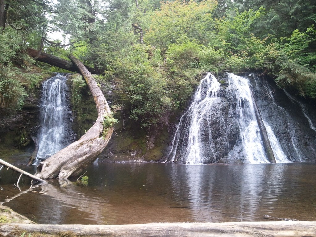
Originally the site of a logging camp in the first part of the 20th century, Cherry Creek Falls is now a popular place for locals (and visitors) to cool off after the hike in. The 25-foot falls are the final waterfall along Cherry Creek. The falls drop over a wide, rocky ledge into a large pool. This pool is inviting to hikers, but as always with waterfalls, be careful when splashing and playing in rocky areas.

Cherry Creek flows well all year long, but by autumn the left-hand side of the falls usually dries up.

From where you park, follow the road-turned-trail behind the gate and the corresponding junctions as follows. There is no trail access near road signs marked Private or No Parking.

At three-quarters of a mile you’ll cross Margaret Creek on a bridge. Shortly after that, stay left at the first junction and right at the second, ignoring any grassy overgrown roads.

After climbing a short hill, stay right at the third junction and proceed downhill. At 1.5 miles, the road makes a sharp hairpin to the right. Head left on a muddy track through the woods. Stay left at next junction to then rejoin the overgrown road. Taking a right at this junction leads you past a crashed car in the trees. Stay straight for another mile, hopping across a few creeks then arrive at Hannan Creek, a large washout that has been leveled by machinery. Ford the creek--walking sticks left by other hikers can be of assistance here.

The trail to the falls branches off to the right on the other side of Hannan Creek. It may be hidden from view by a large dirt pile. Follow the sound of the falls, and shortly a firepit area is reached, which overlooks the falls. There is a short path leading to the base of the falls, a total of two and a half miles from the trailhead.

Hike Description Written by
Multiple authors contributed to this report, WTA Community

Cherry Creek Falls

Map & Directions

Trailhead
Co-ordinates: 47.7457, -121.9076 Open in Google Maps

Before You Go

Respect the neighborhood this hike is in. Observe leash laws, pack out waste and keep noise levels to a minimum and be kind to residents.

See weather forecast

Parking Pass/Entry Fee

None

WTA Pro Tip: Save a copy of our directions before you leave! App-based driving directions aren't always accurate and data connections may be unreliable as you drive to the trailhead.

Getting There

The first half mile of this trail is a courtesy easement within private property. There is no designated public parking area for for Cherry Creek Falls. Look for signs indicating this and do not park where roads are signed "Private Road." 

Cars illegally parked on the road may be ticketed or towed.

There are no toilets at the trailhead. The nearest public bathroom is at McCormick Park in Duvall. Plan accordingly. 

From the junction of SR 203 and Woodinville-Duvall Road in downtown Duvall, head north on SR 203 for about 500 feet, then turn right on NE Cherry Valley Road. Follow this road for 4.3 miles to Mountain View Road, turn left and park on the west shoulder of Mountain View Road. Parking is limited to the shoulder of Mountain View Road only. There is no trail access near road signs marked Private or No Parking.

More Hike Details

Trailhead

Central Cascades > Stevens Pass - West

Washington State Department of Natural Resources

You can improve or add to this guidebook entry!

Cherry Creek Falls

761 Trip Reports

Hiked here recently?

Submit a trip report!
 
Trip Reports