Trails for everyone, forever

Home Go Hiking Hiking Guide Franklin Falls

Franklin Falls

Snoqualmie Region > Snoqualmie Pass
47.4131, -121.4428 Map & Directions
Length
2.0 miles, roundtrip
Elevation Gain
400 feet
Highest Point
2,600 feet
Calculated Difficulty About Calculated Difficulty
Easy
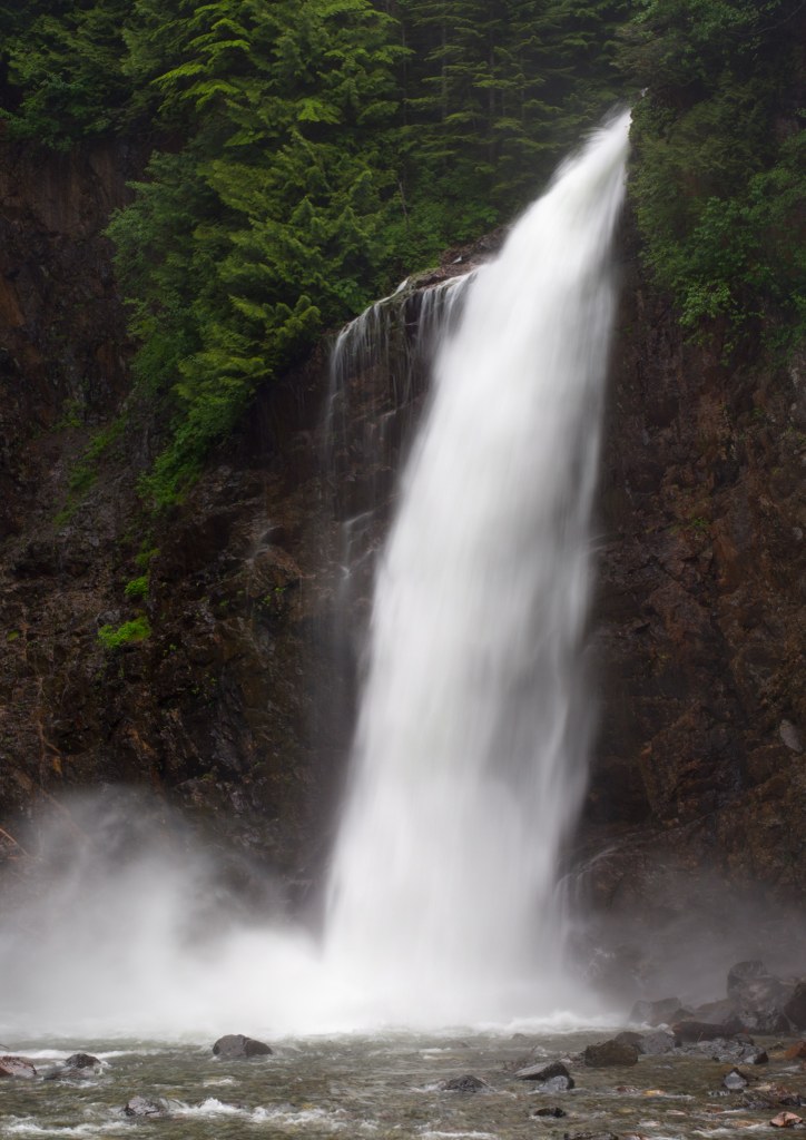
Franklin Falls pounds into its splash pool. Photo by Bobby Marko. Full-size image
Saved to My Backpack

Hiking with kids, new to hiking, or just looking for an easy day hike with a spectacular endpoint? Look no further then Franklin Falls! At just 2 miles with 400 feet in elevation gain it is the perfect destination for any hiker looking for something easy and beautiful! Continue reading

  • Dogs allowed on leash
  • Good for kids
  • Rivers
  • Waterfalls
Rating
4.17 out of 5

(115 votes) Log in to rate

Hiking Franklin Falls

Franklin Falls is a longer hike accessed from a different exit and with avalanche danger in the winter. Please check our Franklin Falls - Winter entry for information on how to enjoy the falls in the winter.

Hiking with kids, new to hiking, or just looking for an easy day hike with a spectacular endpoint? Look no further than Franklin Falls! At just 2 miles roundtrip with 400 feet in elevation gain it is the perfect destination for any hiker looking for something easy and beautiful.

WTA has done trail work here for the last ten years, building walls and rocks steps and constructing bridges to make this trail as safe as possible for even the smallest of hikers. There are a few spots where bits of the trail have been washed out, or handrails haven’t been installed, but overall you can feel confident in bringing your youngsters here for a safe and fun day on the trail. The trail includes a number of stairs with a very gentle incline that is easily hiked. As you hike, you'll be enshrouded in a thick canopy of coniferous trees which makes it a great trail to do on a hot day.

At .7 miles in, the trail draws parallel to National Forest Road 58 for a short time. Just .3 miles further along, you reach picturesque Franklin Falls. The falls are situated between two tall viaducts that allow traffic along I-90 to pass year-round without interference from avalanches in winter. The falls are actually comprised of three separate tiers, giving them a total drop of 135 feet. However, only the last and largest drop can be seen from the trail. At 70 feet, Franklin Falls is a spectacular sight to see, with its best flows between April and July.

There is a viewpoint before reaching the falls but hikers can get closer by following a narrow trail gouged into the side of the rock. Use caution and keep children close as the rocks are often wet and potentially slippery. The falls, when running at peak, give off a pretty heavy spray so rain gear is a good idea if you want to get close. During lower flow periods there is more room to roam by the base of the falls. In the wintertime this also makes an excellent destination for an easy snowshoe, though hikers are well-advised to not venture to the splash pool in icy conditions. The falls run year round and the incredible icicle formations along the rock face around the falls are spectacular--well worth the trip.

There are no garbage receptacles at the trailhead so be sure to pack it out!

Toilet Information

  • Toilet at trailhead

More information about toilets

Wheelchair Accessibility

Franklin Falls is wheelchair friendly for the first 500 feet to a viewpoint of the river.

WTA worked here in 2023, 2022, 2021, 2018, 2017, 2016, 2015, 2014, 2013, 2012 and 2011!

Hike Description Written by
Maura Marko, WTA Correspondent

Franklin Falls

Map & Directions

Trailhead
Co-ordinates: 47.4131, -121.4428 Open in Google Maps

Before You Go

See weather forecast

WTA Pro Tip: Save a copy of our directions before you leave! App-based driving directions aren't always accurate and data connections may be unreliable as you drive to the trailhead.

Getting There

From Seattle, head east on I-90 to exit 47 Denny Creek/Tinkham Road. At the top of the exit ramp, turn left and cross over the freeway. Go 0.2 miles and turn right at the stop sign onto Forest Road 58.

The road crosses under the freeway, after driving 0.2 miles, turn left. Continue straight on for 2.9 miles and about a half mile past the Denny Creek Campground there are three large parking lots on the right that can accommodate about 170 cars.

There is an electronic payment station at the first parking lot for those who do not have a valid pass. Road side parking is not permitted in this area so make sure you have an alternate location in mind if the parking areas are full.

Various connector trails lead from the parking lots to the Denny Creek and Franklin Falls trails.

There is ADA parking available nearer the Franklin Falls trailhead. Be sure to have a placard; parking patrols are on and will ticket violaters.

More Hike Details

Trailhead

Snoqualmie Region > Snoqualmie Pass

Franklin Falls (#1036)

Mt. Baker-Snoqualmie National Forest, Snoqualmie Ranger District

Guidebooks & Maps

Day Hiking Snoqualmie Region: Cascades Foothills | I-90 Corridor | Alpine Lakes (Nelson - Mountaineers Books)

Best Hikes with Kids - Western Washington & the Cascades (Burton - Mountaineers Books)

Buy the Green Trails Snoqualmie Pass No. 207 map

Download a map to plan your hike

You can improve or add to this guidebook entry!

Franklin Falls

1287 Trip Reports

Hiked here recently?

Submit a trip report!
 
Trip Reports